


Hughes Voting District, Nodaway County, Missouri
About
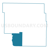
Outline

Summary
| Unique Area Identifier | 609254 |
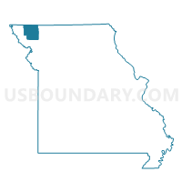
| Name | Hughes Voting District |
| County | Nodaway County |
| State | Missouri |
| Area (square miles) | 64.27 |
| Land Area (square miles) | 64.22 |
| Water Area (square miles) | 0.06 |
| % of Land Area | 99.91 |
| % of Water Area | 0.09 |
| Latitude of the Internal Point | 40.19491580 |
| Longtitude of the Internal Point | -94.99940820 |
Maps

Graphs
Select a template below for downloading or customizing gragh for Hughes Voting District, Nodaway County, Missouri


Neighbors
Neighoring Voting District (by Name) Neighboring Voting District on the Map
- Clay Voting District, Andrew County, MO
- Monroe Voting District, Nodaway County, MO
- Northeast Voting District, Holt County, MO
- Polk E Voting District, Nodaway County, MO
- Southeast Voting District, Holt County, MO
- White Cloud Voting District, Nodaway County, MO
Top 10 Neighboring County Subdivision (by Population) Neighboring County Subdivision on the Map
- Polk township, Nodaway County, MO (15,777)
- Clay township, Holt County, MO (522)
- White Cloud township, Nodaway County, MO (474)
- Hughes township, Nodaway County, MO (426)
- Monroe township, Nodaway County, MO (419)
- Clay township, Andrew County, MO (259)
- Hickory township, Holt County, MO (189)
Top 10 Neighboring Place (by Population) Neighboring Place on the Map
Top 10 Neighboring Unified School District (by Population) Neighboring Unified School District on the Map
- Maryville R-II Schools, MO (15,911)
- North Andrew County R-VI School District, MO (1,898)
- Nodaway-Holt R-VII School District, MO (1,574)
Top 10 Neighboring State Legislative District Lower Chamber (by Population) Neighboring State Legislative District Lower Chamber on the Map
Top 10 Neighboring State Legislative District Upper Chamber (by Population) Neighboring State Legislative District Upper Chamber on the Map
Top 10 Neighboring 111th Congressional District (by Population) Neighboring 111th Congressional District on the Map
Top 10 Neighboring Census Tract (by Population) Neighboring Census Tract on the Map
- Census Tract 4702, Nodaway County, MO (2,762)
- Census Tract 103, Andrew County, MO (2,063)
- Census Tract 9601, Holt County, MO (1,432)